EARLY INHABITANTS
Resting on a ridge overlooking the River Tyne to the north, with its tributary rivers the Derwent and Team to the west and east respectively, the area has produced evidence of Bronze Age and Iron Age inhabitants. In 1970, aerial photography revealed the crop marks of a multi-period Roman fort south-east of the village at Washingwells. The fort is on private land and has not been excavated, but it may either belong to an early Roman frontier which preceded Hadrian's Wall (built c130 AD) or perhaps more likely be the site of marching camps built by Roman units heading north.[1]
The name "Whickham" is Anglo-Saxon, meaning "estate with a quickset hedge", but nothing is heard of Whickham until well after the Norman Conquest. It is in the Boldon Book, compiled for the Bishop of Durham in 1183, that we have the first documentary evidence of life in the village. In "Quykham" the Bishop had 35 tenants, each of whom held an ox gang of land (about 15 acres). In return, the tenants paid 16d rent and were obliged to perform the following services for their lord: work for the Bishop three days per week; carry the Bishop's baggage between Durham and Bedlington when required; serve in his fishery in the Tyne; provide a cow, a hen and 10 eggs and pay 9s cornage rent (the Bishop controlled the milling of corn for flour).[2]
The Boldon Book shows Whickham as a small agricultural community, clustered around a green. Indeed, the ghost of this village is there for us to see if we only look. Based on similar Durham villages, such as West Auckland, we can imagine a village with two rows of houses. The northern row, on the edge of the slope down to Swalwell, would possibly have extended along the line of Church Chare, with the Rectory and Church of St. Mary the Virgin in the middle, and along School Lane, with outlying houses around the sites of Whickham Park and Dockendale Hall. The southern row of houses probably stood on the rising ground now occupied by Chase Park. Until 1960, Chase Hall, a private house, stood here. We can recall, however, other cases in the North East (such as Bywell, Belsay and Howick) where a wealthy family bought up land, flattened peasant houses and created a private house and estate where several poor families had once lived. This may have been the fate of the southern row of medieval houses. Between the northern and southern rows was the village green. Today, only a tiny remnant remains, itself saved from development in 1852 by the prompt action of the Rector, Rev. H. B. Carr. The green would have been much more extensive, since it would have accommodated the villagers' livestock during the night. This would have been vital during the "troublesome times" when Scottish raiders were about from the fourteenth to the sixteenth centuries.
To the west, east and south of the houses and the village green would have been the fields in which the villagers grew food for themselves and their animals. At the west end of the medieval village, south of the road, was the Glebe. This area, which now contains the Whickham Cottage Health Centre and the Glebe Sports fields, was a substantial area of land belonging to the Rector of Whickham. The Bishop of Durham owned a mill (perhaps close to where the eighteenth century windmill stands in Chase Park), where the villagers were obliged to have their grain ground into flour (at a profit to the Bishop and the miller).
AGRICULTURE
Agriculture was and is an important part of Whickham history, but has often been overshadowed by the coal industry. We should remember that the first, prehistoric inhabitants of Whickham were attracted by the agricultural potential of the lands above the River Tyne. It is no coincidence that their remains were discovered in the vicinity of the modern Washingwell and Marshall Lands farms, since the same land was as valuable to farmers in prehistory as it is today. Until the mid-Twentieth Centuries, there were three farms on Front Street and Whickham Highway (Glebe Farm, Cross Farm and Dunston West Farm). It is the surviving farms around Whickham that provide the green belt around the town and preserve the air of seclusion one feels when driving into Whickham from Whickham Highway and Fellside Road.
COAL
The rural landscape of Whickham, given over to agriculture and livestock, was to be disturbed for centuries by another industry. The effects of this industry upon the landscape are fast receding. Whickham is once again ringed by green fields and Gateshead Council has successfully redeveloped the last major sites, in the Whickham area, of the industry for which County Durham was famous: coal. Coal was available close to the surface across Whickham, and it is likely that it was used as a domestic fuel for centuries. However, it was not until the fourteenth century that its use became more widespread, principally as a fuel to heat limestone to create lime for improving the productivity of fields. In 1356 the Bishop of Durham granted a lease of the coal mines in the Manor of Whickham; this was the first documentary evidence of the industry which was to dominate Whickham until 1964. When the surface coal was exhausted, miners dug deeper and deeper pits to reach the "black gold". The terrible human costs of mining are evident from the grim regularity of "killed in a pit" in the Parish Registers of Whickham. In the 16th century, national demand saw wealthy merchants and landowners buying up the lands around Whickham to maximise production, to the consternation of villagers whose lands, crops and roads were ruined by the stream of wains (waggons) carrying the coal down to ships waiting in the Tyne. It has been estimated that Whickham mines supplied 17000 tons of coal one year in the 1520s. By the 1590s the estimated figure was 40000 tons, by 1636 nearly 90000 tons[3]. By the beginning of the 18th century, the most productive mines were outside the village, but mining continued. The last mine to open in Whickham, Watergate Colliery, opened in 1924, closing in 1964. The site of the colliery has recently been reclaimed as a public park, but the housing estate built for the miners on Broom Lane survives. The coal owners who made their money from the sweat of the miners are gone and the great houses they built survive in varying states of disrepair. At Gibside, the Bowes family mansion stands roofless, surrounded by landscaped grounds and near the beautiful Chapel they built as their mausoleum; the estate is now owned by the National Trust. Dunston Hill, half a mile from Whickham, home of the Carr-Ellisons, was used as a hospital until recent years. After many years of dereliction, it has been converted into apartments. Axwell Hall, home of the Claverings, is being converted into apartments. Ravensworth Castle, home of the Liddells, had to be demolished in the 1950s because of subsidence from the very mines that had paid for its reconstruction. The two surviving towers from the medieval castle stand alongside the scant remains of the Liddells' mansion. The estate is not open to visitors.
WAGGONWAYS
The huge amounts of coal produced in Whickham were more than the primitive roads could cope with; a more reliable and less restricted transport system was required. A law suit in 1622 is evidence for the first Tyneside waggonway. A waggonway was a wooden railway upon which the coal wains could be drawn by horses to the river. The waggonways were expensive to build and maintain, but eased the transport problem for the coal-owners. Some routes of these waggonways can be seen around the outskirts of Whickham and the Causey Arch, 3 miles south of Whickham, is the world's oldest railway bridge, built in 1727. The Tanfield Railway, which the Arch was built to serve, is still operated by volunteers, making it the world's oldest working railway.
WAR
Throughout history the people of Whickham have needed to defend themselves and their land. The village’s position on the crest of a ridge overlooking the Tyne, Derwent and Team valleys, with fertile agricultural land to the south, made it attractive to early farmers. But let us think again about the name of Whickham. “Estate with a quickset hedge” means that this settlement on top of its steep hill, was surrounded by a hawthorn hedge. This would keep cattle in, and anyone who has tried to pass a hawthorn hedge knows that it is a very successful means of keeping unwanted intruders out: it is nature’s equivalent of barbed wire. So perhaps the Anglo Saxons, in naming the village, perpetuated this defensive precaution.
Following the Norman Conquest there were rebellions in County Durham against the new rulers, including the murder of the Norman Bishop of Durham, Walcher, at Gateshead in 1070. William the Conqueror responded to these rebellions with increasing savagery, destroying villages, livestock and crops. The records are silent, but it is likely that the people of Whickham were affected by these upheavals. Like many communities, the people of Whickham would have suffered the deprivations and uncertainties of living close to an enemy nation, as Scotland was for many centuries. There were raids into northern England by King William the Lion of Scotland in 1173, when he burned to death the inhabitants of Warkworth in their church, but there followed a period of relative peace until 1296, when king Edward I of England started what was to become over 300 years of warfare, raiding and cross-border strife. Though the English were usually successful in battle, little could be done to prevent Scottish raiders plunging deep into Durham. Following the Scottish victory at Bannockburn in 1314, King Robert the Bruce of Scotland destroyed villages across Northumberland and Durham. English armies heading towards Scotland often passed through Whickham, travelling down Clockburn Lane to ford the Derwent and then on to the ford over the River Tyne at Newburn, west of Newcastle. Scottish armies could travel in the opposite direction. In 1346, King David II of Scotland invaded England and crossed the River Tyne at Newburn, almost certainly passing through Whickham parish on his way south.[4] His army was eventually defeated at Neville's Cross near Durham, but not before several villages had been sacked.
The two oldest buildings in Whickham show evidence of defence against this Scottish threat. On the south-west outskirts of Whickham, near Clockburn Lane, stands Old Hollinside, a fortified manor house built in the 14th century. It is now an attractive ruin, but it retains the defensive features that were so necessary in Northern houses between the 13th and the 17th centuries, such as drawbar slots and small windows on the lower floors. At Hollinside the entrance is between two projecting wings, the space between arched over to carry a defensive turret. There is another projecting turret at the rear of the house, which stands on the edge of a steep hill overlooking the River Derwent. Being so close to the path of any Scottish invaders the owners of Old Hollinside had to give at least the pretence of fortification. They could not hope to resist a Scottish army, but raiders might think twice, especially if, as suggested by Peter Ryder [5], the earthworks shown on the 1856 Ordnance Survey map of Hollinside indicate that the house was once further protected by a curtain wall and gatehouse.
The tower of the parish church also shows some evidence of defensive use. The ground floor is covered by a stone-vaulted roof. This measure was often used to fireproof the tower and turn it into a refuge during Scottish raids. The antiquarian Bourn tells us that the door above this vault was originally the only entrance to the upper parts of the tower, another feature enhancing its security. There are extensive views from the roof of the tower, to east and west along the valley and northwards into Northumberland. If a warning beacon was placed upon this tower, it would be visible to friendly forces for miles around.
During the English Civil War, Parliament's Scottish allies defeated the King's army at the Newburn ford in 1640. Once again, the church tower would have provided the ideal vantage point to observe the advance of Scottish troops. The King's soldiers had camped in the fields below Whickham and in the retreat they set fire to their tents, igniting a seam of coal which burned for many years after. Oliver Cromwell stayed in Whickham in 1648. He often humiliated his enemies by occupying their houses and is said to have stayed in Dockendale Hall.
Whickham played its part in the two World Wars. The “valiant hearts” who gave their lives for our freedom are commemorated at the War Memorial on the village green. This remains relevant today, as the recent addition of David Watson, killed in Afghanistan, reminds us. During the First World War, part of the Rectory of 1713 was used to assemble shells. It served a more peaceful purpose after 1922 when it became the War Memorial Cottage Hospital and after use as a school it is now a health centre. During the First World War, soldiers camped at Gibside Hall, south of Whickham, and during the Second World War they were billeted at Ravensworth Castle. Anti-aircraft guns were positioned around Whickham to combat German aircraft heading for the shipyards and munitions factories at Elswick. Another interesting and virtually unknown reminder of the anti-invasion preparations from World War II can be seen around the allotments at Watergate, where rifle slits have been let into the wall to cover the farmland on the eastern side of the village. Down beside the River Tyne at Dunston there is a machine-gun pillbox positioned against the railway embankment near the Federation Brewery. It faces west, and a similar pillbox stood where IKEA is now. Between them, their machine-guns were intended to mow down any German glider-troops or paratroops who landed in this area, which was close to the shipyards and arms factories at Elswick. Until recently, air raid shelters built for factory workers survived at First Avenue on the Team Valley and several examples of Anderson shelters supplied for family protection remain throughout the area.
RELIGION
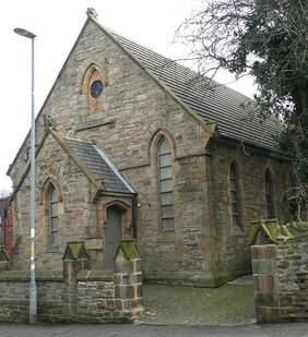
The oldest building in Whickham is the parish church of St. Mary the Virgin. The earliest parts are Norman, including the priest's door into the south side of the chancel. The rugged and battlemented west tower dates from the 14th century. Much of the north side of the church dates from a restoration of 1819 by John Dobson and even more from Anthony Salvin's reconstruction of 1860-62. The churchyard contains many fine monuments, most notably that of Harry Clasper, a Victorian oarsman and boat builder, and one for William Shield, Master of the King’s Music and composer of the tune of ‘Auld Lang Syne’.
As with many mining villages, Whickham has a strong Methodist tradition. John Wesley was here in 1742 and 1752 and the village has two Methodist chapels. The earliest, the West End Wesleyan Chapel of 1869 is now a community church and the Methodist congregation now worships at Fellside Methodist Church. The Spoor Memorial Methodist Chapel of 1871 commemorates Joseph Spoor, a keelman who became a travelling Methodist preacher.
During the Reformation of the 16th century Catholicism in Whickham was all but extinguished, though two men were hanged on the village green for their part in the 1569 rebellion by the earls of Northumberland and Westmorland. There are references to Whickham "papists" in the Durham Court records and some of the great coal barons who controlled mines in and around Whickham were Catholics. However, it was 1948 before a Catholic church was built in Whickham, when the Church purchased the Dockendale Hall Estate.[6]
REFERENCES
[1] Holbrook, N. & Speak, S., ‘Washingwells Roman fort: a transcription of the aerial photographs and an assessment of the evidence, The Arbeia Journal, volume 3, 1994.
[2] Bourn, W., Whickham parish: its history, antiquities and industries, 1893 (Republished by Gateshead Council, 1999, ISBN 090127335X).
[3] Levine, D. & Wrightson, K. The Making of an industrial society: Whickham 1560 - 1765 (Oxford University Press, 1991, ISBN 0198200668).
[4] Durham County Council, Battle of Neville's Cross: an illustrated history (Durham, 1996).
[5] Ryder, P.F. ‘Old Hollinside’ in Archaeology North volume 9, Summer 1995, pp.6-9.
[6] Rix, T. St. Mary' s Dockendale: a short history, 1988.
Further research sources
Please note that Whickham History Society does not have any archival material. A very informative introduction to the history of Whickham is Alan Brazendale, Whickham: History and Guide (Tempus, 2001). If you are interested in researching people, places or events relevant to Whickham, relevant sources can be found in Gateshead Local Studies Library, Tyne and Wear Archives and Museums, Durham County Record Office, Durham University Special Collections and Northumberland Record Office. The Society is unable to assist with family history enquiries.
Resting on a ridge overlooking the River Tyne to the north, with its tributary rivers the Derwent and Team to the west and east respectively, the area has produced evidence of Bronze Age and Iron Age inhabitants. In 1970, aerial photography revealed the crop marks of a multi-period Roman fort south-east of the village at Washingwells. The fort is on private land and has not been excavated, but it may either belong to an early Roman frontier which preceded Hadrian's Wall (built c130 AD) or perhaps more likely be the site of marching camps built by Roman units heading north.[1]
The name "Whickham" is Anglo-Saxon, meaning "estate with a quickset hedge", but nothing is heard of Whickham until well after the Norman Conquest. It is in the Boldon Book, compiled for the Bishop of Durham in 1183, that we have the first documentary evidence of life in the village. In "Quykham" the Bishop had 35 tenants, each of whom held an ox gang of land (about 15 acres). In return, the tenants paid 16d rent and were obliged to perform the following services for their lord: work for the Bishop three days per week; carry the Bishop's baggage between Durham and Bedlington when required; serve in his fishery in the Tyne; provide a cow, a hen and 10 eggs and pay 9s cornage rent (the Bishop controlled the milling of corn for flour).[2]
The Boldon Book shows Whickham as a small agricultural community, clustered around a green. Indeed, the ghost of this village is there for us to see if we only look. Based on similar Durham villages, such as West Auckland, we can imagine a village with two rows of houses. The northern row, on the edge of the slope down to Swalwell, would possibly have extended along the line of Church Chare, with the Rectory and Church of St. Mary the Virgin in the middle, and along School Lane, with outlying houses around the sites of Whickham Park and Dockendale Hall. The southern row of houses probably stood on the rising ground now occupied by Chase Park. Until 1960, Chase Hall, a private house, stood here. We can recall, however, other cases in the North East (such as Bywell, Belsay and Howick) where a wealthy family bought up land, flattened peasant houses and created a private house and estate where several poor families had once lived. This may have been the fate of the southern row of medieval houses. Between the northern and southern rows was the village green. Today, only a tiny remnant remains, itself saved from development in 1852 by the prompt action of the Rector, Rev. H. B. Carr. The green would have been much more extensive, since it would have accommodated the villagers' livestock during the night. This would have been vital during the "troublesome times" when Scottish raiders were about from the fourteenth to the sixteenth centuries.
To the west, east and south of the houses and the village green would have been the fields in which the villagers grew food for themselves and their animals. At the west end of the medieval village, south of the road, was the Glebe. This area, which now contains the Whickham Cottage Health Centre and the Glebe Sports fields, was a substantial area of land belonging to the Rector of Whickham. The Bishop of Durham owned a mill (perhaps close to where the eighteenth century windmill stands in Chase Park), where the villagers were obliged to have their grain ground into flour (at a profit to the Bishop and the miller).
AGRICULTURE
Agriculture was and is an important part of Whickham history, but has often been overshadowed by the coal industry. We should remember that the first, prehistoric inhabitants of Whickham were attracted by the agricultural potential of the lands above the River Tyne. It is no coincidence that their remains were discovered in the vicinity of the modern Washingwell and Marshall Lands farms, since the same land was as valuable to farmers in prehistory as it is today. Until the mid-Twentieth Centuries, there were three farms on Front Street and Whickham Highway (Glebe Farm, Cross Farm and Dunston West Farm). It is the surviving farms around Whickham that provide the green belt around the town and preserve the air of seclusion one feels when driving into Whickham from Whickham Highway and Fellside Road.
COAL
The rural landscape of Whickham, given over to agriculture and livestock, was to be disturbed for centuries by another industry. The effects of this industry upon the landscape are fast receding. Whickham is once again ringed by green fields and Gateshead Council has successfully redeveloped the last major sites, in the Whickham area, of the industry for which County Durham was famous: coal. Coal was available close to the surface across Whickham, and it is likely that it was used as a domestic fuel for centuries. However, it was not until the fourteenth century that its use became more widespread, principally as a fuel to heat limestone to create lime for improving the productivity of fields. In 1356 the Bishop of Durham granted a lease of the coal mines in the Manor of Whickham; this was the first documentary evidence of the industry which was to dominate Whickham until 1964. When the surface coal was exhausted, miners dug deeper and deeper pits to reach the "black gold". The terrible human costs of mining are evident from the grim regularity of "killed in a pit" in the Parish Registers of Whickham. In the 16th century, national demand saw wealthy merchants and landowners buying up the lands around Whickham to maximise production, to the consternation of villagers whose lands, crops and roads were ruined by the stream of wains (waggons) carrying the coal down to ships waiting in the Tyne. It has been estimated that Whickham mines supplied 17000 tons of coal one year in the 1520s. By the 1590s the estimated figure was 40000 tons, by 1636 nearly 90000 tons[3]. By the beginning of the 18th century, the most productive mines were outside the village, but mining continued. The last mine to open in Whickham, Watergate Colliery, opened in 1924, closing in 1964. The site of the colliery has recently been reclaimed as a public park, but the housing estate built for the miners on Broom Lane survives. The coal owners who made their money from the sweat of the miners are gone and the great houses they built survive in varying states of disrepair. At Gibside, the Bowes family mansion stands roofless, surrounded by landscaped grounds and near the beautiful Chapel they built as their mausoleum; the estate is now owned by the National Trust. Dunston Hill, half a mile from Whickham, home of the Carr-Ellisons, was used as a hospital until recent years. After many years of dereliction, it has been converted into apartments. Axwell Hall, home of the Claverings, is being converted into apartments. Ravensworth Castle, home of the Liddells, had to be demolished in the 1950s because of subsidence from the very mines that had paid for its reconstruction. The two surviving towers from the medieval castle stand alongside the scant remains of the Liddells' mansion. The estate is not open to visitors.
WAGGONWAYS
The huge amounts of coal produced in Whickham were more than the primitive roads could cope with; a more reliable and less restricted transport system was required. A law suit in 1622 is evidence for the first Tyneside waggonway. A waggonway was a wooden railway upon which the coal wains could be drawn by horses to the river. The waggonways were expensive to build and maintain, but eased the transport problem for the coal-owners. Some routes of these waggonways can be seen around the outskirts of Whickham and the Causey Arch, 3 miles south of Whickham, is the world's oldest railway bridge, built in 1727. The Tanfield Railway, which the Arch was built to serve, is still operated by volunteers, making it the world's oldest working railway.
WAR
Throughout history the people of Whickham have needed to defend themselves and their land. The village’s position on the crest of a ridge overlooking the Tyne, Derwent and Team valleys, with fertile agricultural land to the south, made it attractive to early farmers. But let us think again about the name of Whickham. “Estate with a quickset hedge” means that this settlement on top of its steep hill, was surrounded by a hawthorn hedge. This would keep cattle in, and anyone who has tried to pass a hawthorn hedge knows that it is a very successful means of keeping unwanted intruders out: it is nature’s equivalent of barbed wire. So perhaps the Anglo Saxons, in naming the village, perpetuated this defensive precaution.
Following the Norman Conquest there were rebellions in County Durham against the new rulers, including the murder of the Norman Bishop of Durham, Walcher, at Gateshead in 1070. William the Conqueror responded to these rebellions with increasing savagery, destroying villages, livestock and crops. The records are silent, but it is likely that the people of Whickham were affected by these upheavals. Like many communities, the people of Whickham would have suffered the deprivations and uncertainties of living close to an enemy nation, as Scotland was for many centuries. There were raids into northern England by King William the Lion of Scotland in 1173, when he burned to death the inhabitants of Warkworth in their church, but there followed a period of relative peace until 1296, when king Edward I of England started what was to become over 300 years of warfare, raiding and cross-border strife. Though the English were usually successful in battle, little could be done to prevent Scottish raiders plunging deep into Durham. Following the Scottish victory at Bannockburn in 1314, King Robert the Bruce of Scotland destroyed villages across Northumberland and Durham. English armies heading towards Scotland often passed through Whickham, travelling down Clockburn Lane to ford the Derwent and then on to the ford over the River Tyne at Newburn, west of Newcastle. Scottish armies could travel in the opposite direction. In 1346, King David II of Scotland invaded England and crossed the River Tyne at Newburn, almost certainly passing through Whickham parish on his way south.[4] His army was eventually defeated at Neville's Cross near Durham, but not before several villages had been sacked.
The two oldest buildings in Whickham show evidence of defence against this Scottish threat. On the south-west outskirts of Whickham, near Clockburn Lane, stands Old Hollinside, a fortified manor house built in the 14th century. It is now an attractive ruin, but it retains the defensive features that were so necessary in Northern houses between the 13th and the 17th centuries, such as drawbar slots and small windows on the lower floors. At Hollinside the entrance is between two projecting wings, the space between arched over to carry a defensive turret. There is another projecting turret at the rear of the house, which stands on the edge of a steep hill overlooking the River Derwent. Being so close to the path of any Scottish invaders the owners of Old Hollinside had to give at least the pretence of fortification. They could not hope to resist a Scottish army, but raiders might think twice, especially if, as suggested by Peter Ryder [5], the earthworks shown on the 1856 Ordnance Survey map of Hollinside indicate that the house was once further protected by a curtain wall and gatehouse.
The tower of the parish church also shows some evidence of defensive use. The ground floor is covered by a stone-vaulted roof. This measure was often used to fireproof the tower and turn it into a refuge during Scottish raids. The antiquarian Bourn tells us that the door above this vault was originally the only entrance to the upper parts of the tower, another feature enhancing its security. There are extensive views from the roof of the tower, to east and west along the valley and northwards into Northumberland. If a warning beacon was placed upon this tower, it would be visible to friendly forces for miles around.
During the English Civil War, Parliament's Scottish allies defeated the King's army at the Newburn ford in 1640. Once again, the church tower would have provided the ideal vantage point to observe the advance of Scottish troops. The King's soldiers had camped in the fields below Whickham and in the retreat they set fire to their tents, igniting a seam of coal which burned for many years after. Oliver Cromwell stayed in Whickham in 1648. He often humiliated his enemies by occupying their houses and is said to have stayed in Dockendale Hall.
Whickham played its part in the two World Wars. The “valiant hearts” who gave their lives for our freedom are commemorated at the War Memorial on the village green. This remains relevant today, as the recent addition of David Watson, killed in Afghanistan, reminds us. During the First World War, part of the Rectory of 1713 was used to assemble shells. It served a more peaceful purpose after 1922 when it became the War Memorial Cottage Hospital and after use as a school it is now a health centre. During the First World War, soldiers camped at Gibside Hall, south of Whickham, and during the Second World War they were billeted at Ravensworth Castle. Anti-aircraft guns were positioned around Whickham to combat German aircraft heading for the shipyards and munitions factories at Elswick. Another interesting and virtually unknown reminder of the anti-invasion preparations from World War II can be seen around the allotments at Watergate, where rifle slits have been let into the wall to cover the farmland on the eastern side of the village. Down beside the River Tyne at Dunston there is a machine-gun pillbox positioned against the railway embankment near the Federation Brewery. It faces west, and a similar pillbox stood where IKEA is now. Between them, their machine-guns were intended to mow down any German glider-troops or paratroops who landed in this area, which was close to the shipyards and arms factories at Elswick. Until recently, air raid shelters built for factory workers survived at First Avenue on the Team Valley and several examples of Anderson shelters supplied for family protection remain throughout the area.
RELIGION
The oldest building in Whickham is the parish church of St. Mary the Virgin. The earliest parts are Norman, including the priest's door into the south side of the chancel. The rugged and battlemented west tower dates from the 14th century. Much of the north side of the church dates from a restoration of 1819 by John Dobson and even more from Anthony Salvin's reconstruction of 1860-62. The churchyard contains many fine monuments, most notably that of Harry Clasper, a Victorian oarsman and boat builder, and one for William Shield, Master of the King’s Music and composer of the tune of ‘Auld Lang Syne’.
As with many mining villages, Whickham has a strong Methodist tradition. John Wesley was here in 1742 and 1752 and the village has two Methodist chapels. The earliest, the West End Wesleyan Chapel of 1869 is now a community church and the Methodist congregation now worships at Fellside Methodist Church. The Spoor Memorial Methodist Chapel of 1871 commemorates Joseph Spoor, a keelman who became a travelling Methodist preacher.
During the Reformation of the 16th century Catholicism in Whickham was all but extinguished, though two men were hanged on the village green for their part in the 1569 rebellion by the earls of Northumberland and Westmorland. There are references to Whickham "papists" in the Durham Court records and some of the great coal barons who controlled mines in and around Whickham were Catholics. However, it was 1948 before a Catholic church was built in Whickham, when the Church purchased the Dockendale Hall Estate.[6]
REFERENCES
[1] Holbrook, N. & Speak, S., ‘Washingwells Roman fort: a transcription of the aerial photographs and an assessment of the evidence, The Arbeia Journal, volume 3, 1994.
[2] Bourn, W., Whickham parish: its history, antiquities and industries, 1893 (Republished by Gateshead Council, 1999, ISBN 090127335X).
[3] Levine, D. & Wrightson, K. The Making of an industrial society: Whickham 1560 - 1765 (Oxford University Press, 1991, ISBN 0198200668).
[4] Durham County Council, Battle of Neville's Cross: an illustrated history (Durham, 1996).
[5] Ryder, P.F. ‘Old Hollinside’ in Archaeology North volume 9, Summer 1995, pp.6-9.
[6] Rix, T. St. Mary' s Dockendale: a short history, 1988.
Further research sources
Please note that Whickham History Society does not have any archival material. A very informative introduction to the history of Whickham is Alan Brazendale, Whickham: History and Guide (Tempus, 2001). If you are interested in researching people, places or events relevant to Whickham, relevant sources can be found in Gateshead Local Studies Library, Tyne and Wear Archives and Museums, Durham County Record Office, Durham University Special Collections and Northumberland Record Office. The Society is unable to assist with family history enquiries.
